Thank you for supporting this site ❤️
Make a donation
Make a donation
Gear up for your next adventure:
As an Amazon Associate, this site earns from qualifying purchases at no extra cost to you.
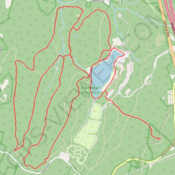
Greenbrier State Park Hiking Loop
- Distance: 16.1 Km
- Elevation gain: 535 m
- Maximum elevation: 429 m
- Elevation loss: 535 m
- Minimum elevation: 199 m
Interactive trail map
Thank you for supporting this site ❤️
Make a donation
Make a donation
Gear up for your next adventure:
As an Amazon Associate, this site earns from qualifying purchases at no extra cost to you.
Trail profile
- Distance: 16.1 Km
- Elevation gain: 535 m
- Maximum elevation: 429 m
- Elevation loss: 535 m
- Minimum elevation: 199 m
Thank you for supporting this site ❤️
Make a donation
Make a donation
Gear up for your next adventure:
As an Amazon Associate, this site earns from qualifying purchases at no extra cost to you.
About this trail
Name: Greenbrier State Park Hiking Loop trail, distance, elevation, map, profile, GPS track
Start: Camp Loop Trail, Washington County, Maryland, 21713, United States (39.53551 -77.62038)
End: Camp Loop Trail, Washington County, Maryland, 21713, United States (39.53553 -77.62031)
Coordinates: 39.52685 -77.63360 39.54697 -77.60988
Thank you for supporting this site ❤️
Make a donation
Make a donation
Gear up for your next adventure:
As an Amazon Associate, this site earns from qualifying purchases at no extra cost to you.