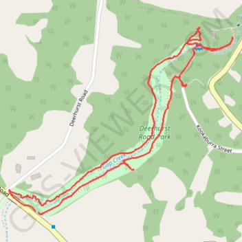
Deerhurst Road Park
Loop hike / run along Gap Creek through Deerhurst Road Park in Kenmore Hills. #Hiking #Running #Loop #Park #Nature #Forest #River
- Distance: 2.9 Km
- Elevation gain: 20 m
- Maximum elevation: 45 m
- Elevation loss: 20 m
- Minimum elevation: 31 m
- Moving time: 33 m 25 s
- Moving speed: 5.2 Km/h
- Maximum speed: 11.2 Km/h
- Total time: 35 m 16 s
- Global speed: 4.9 Km/h
Interactive trail map
Trail profile
- Distance: 2.9 Km
- Elevation gain: 20 m
- Maximum elevation: 45 m
- Elevation loss: 20 m
- Minimum elevation: 31 m
- Moving time: 33 m 25 s
- Moving speed: 5.2 Km/h
- Maximum speed: 11.2 Km/h
- Total time: 35 m 16 s
- Global speed: 4.9 Km/h
About this trail
Name: Deerhurst Road Park trail, distance, elevation, map, profile, GPS track
Coordinates: -27.49537 152.91692 -27.48930 152.92511
Topography: City of Brisbane topographic map, elevation, terrain
Other hiking, mountain biking, running and outdoor activity trails
Click on a trail to view its statistics, map and profile.