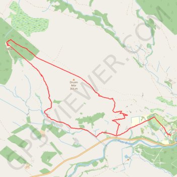
Walk up Drumour and down Tombane
- Distance: 9.3 Km
- Elevation gain: 234 m
- Maximum elevation: 360 m
- Elevation loss: 222 m
- Minimum elevation: 182 m
- Moving time: 3 h 6 m
- Moving speed: 3.0 Km/h
- Maximum speed: 11.1 Km/h
- Total time: 5 h 17 m
- Global speed: 1.8 Km/h
Interactive trail map
Trail profile
- Distance: 9.3 Km
- Elevation gain: 234 m
- Maximum elevation: 360 m
- Elevation loss: 222 m
- Minimum elevation: 182 m
- Moving time: 3 h 6 m
- Moving speed: 3.0 Km/h
- Maximum speed: 11.1 Km/h
- Total time: 5 h 17 m
- Global speed: 1.8 Km/h
About this trail
Name: Walk up Drumour and down Tombane trail, distance, elevation, map, profile, GPS track
Start: A822, Trochry, Perth and Kinross, Scotland, PH8 0BU, United Kingdom (56.53846 -3.69040)
Coordinates: 56.53804 -3.72546 56.55528 -3.67322
Other hiking, mountain biking, running and outdoor activity trails
Click on a trail to view its statistics, map and profile.
Walk up to Creag Liath
United Kingdom > Scotland > Perth and Kinross > Trochry
Distance: 10.9 Km • Elevation gain: 267 m • Maximum elevation: 419 m