Make a donation
Gear up for your next adventure:
As an Amazon Associate, this site earns from qualifying purchases at no extra cost to you.
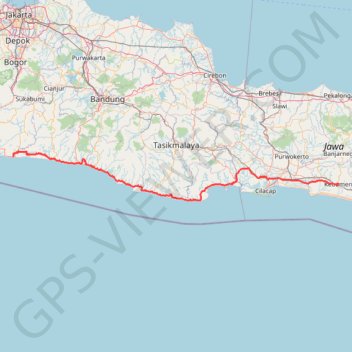
BENTANGJAWA2024_FINAL
- Distance: 428.3 Km
- Elevation gain: 3,937 m
- Maximum elevation: 279 m
- Elevation loss: 3,920 m
- Minimum elevation: -2 m
Interactive trail map
Make a donation
Gear up for your next adventure:
As an Amazon Associate, this site earns from qualifying purchases at no extra cost to you.
Trail profile
- Distance: 428.3 Km
- Elevation gain: 3,937 m
- Maximum elevation: 279 m
- Elevation loss: 3,920 m
- Minimum elevation: -2 m
Make a donation
Gear up for your next adventure:
As an Amazon Associate, this site earns from qualifying purchases at no extra cost to you.
About this trail
Name: BENTANGJAWA2024_FINAL trail, distance, elevation, map, profile, GPS track
End: Jalan Kusuma, Jadi Baru Kebumen, Kebumen, Central Java, Java, 54316, Indonesia (-7.66785 109.66121)
Coordinates: -7.81858 106.77819 -7.38786 109.66147
Make a donation
Gear up for your next adventure:
As an Amazon Associate, this site earns from qualifying purchases at no extra cost to you.
Other hiking, mountain biking, running and outdoor activity trails
Click on a trail to view its statistics, map and profile.
Benjaw day 1
Indonesia > Banten > Pandeglang > Banjarmasin
Distance: 347.1 Km • Elevation gain: 6,365 m • Maximum elevation: 878 m
BENTANGJAWA2024_FINAL
Indonesia > West Java > Sukabumi > Tegalbuleud > Panaruban
Distance: 1,147.2 Km • Elevation gain: 12,308 m • Maximum elevation: 2,460 m
BENTANGJAWA2024_FINAL
Indonesia > West Java > Sukabumi > Tegalbuleud > Panaruban
Distance: 428.3 Km • Elevation gain: 3,937 m • Maximum elevation: 279 m
Benjaw day 3
Indonesia > Central Java > Kebumen > Bumirejo
Distance: 356.8 Km • Elevation gain: 4,241 m • Maximum elevation: 588 m
Make a donation
Gear up for your next adventure:
As an Amazon Associate, this site earns from qualifying purchases at no extra cost to you.
Benjaw day 3
Indonesia > Central Java > Kebumen > Bumirejo
Distance: 356.8 Km • Elevation gain: 4,241 m • Maximum elevation: 588 m
Ciputat Market to Penginapan Pondok Indah Karang Potong
Indonesia > Banten > South Tangerang
Distance: 277.2 Km • Elevation gain: 4,960 m • Maximum elevation: 790 m