Mesa Butte
Kananaskis Country Public Land Use Zone. #Hiking #Kananaskis
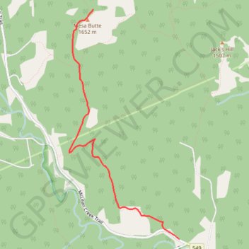
- Distance: 8.1 Km
- Elevation gain: 497 m
- Maximum elevation: 1,686 m
- Elevation loss: 497 m
- Minimum elevation: 1,371 m
Interactive trail map
Trail profile
- Distance: 8.1 Km
- Elevation gain: 497 m
- Maximum elevation: 1,686 m
- Elevation loss: 497 m
- Minimum elevation: 1,371 m
About this trail
Name: Mesa Butte trail, distance, elevation, map, profile, GPS track
Start: McLean Creek Trail, Kananaskis Improvement District, Alberta, Canada (50.75637 -114.54618)
End: McLean Creek Trail, Kananaskis Improvement District, Alberta, Canada (50.75637 -114.54618)
Coordinates: 50.75637 -114.56397 50.78005 -114.54618
Other hiking, mountain biking, running and outdoor activity trails
Click on a trail to view its statistics, map and profile.
Mesa Butte to Sandy McNabb
Canada > Alberta > Kananaskis Improvement District
Distance: 20.1 Km • Elevation gain: 409 m • Maximum elevation: 1,532 m