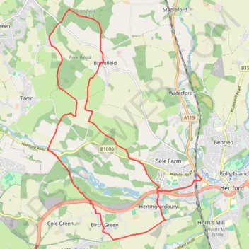
Hertfordshire Chain Walk 5&6
- Distance: 19.8 Km
- Elevation gain: 188 m
- Maximum elevation: 126 m
- Elevation loss: 188 m
- Minimum elevation: 43 m
- Moving time: 3 h 57 m
- Moving speed: 5.0 Km/h
- Maximum speed: 5.4 Km/h
- Total time: 3 h 57 m
- Global speed: 5.0 Km/h
Interactive trail map
Trail profile
- Distance: 19.8 Km
- Elevation gain: 188 m
- Maximum elevation: 126 m
- Elevation loss: 188 m
- Minimum elevation: 43 m
- Moving time: 3 h 57 m
- Moving speed: 5.0 Km/h
- Maximum speed: 5.4 Km/h
- Total time: 3 h 57 m
- Global speed: 5.0 Km/h
About this trail
Name: Hertfordshire Chain Walk 5&6 trail, distance, elevation, map, profile, GPS track
Coordinates: 51.78366 -0.14760 51.83711 -0.08978
Other hiking, mountain biking, running and outdoor activity trails
Click on a trail to view its statistics, map and profile.
Circuit from Stapleford
United Kingdom > England > Hertfordshire > East Hertfordshire > Stapleford
Distance: 21.0 Km • Elevation gain: 181 m • Maximum elevation: 125 m