Make a donation
Gear up for your next adventure:
As an Amazon Associate, this site earns from qualifying purchases at no extra cost to you.
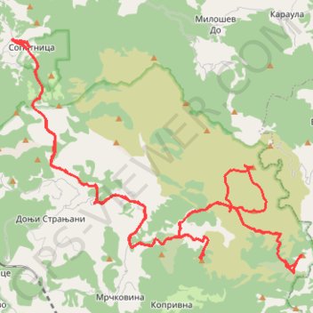
Track
- Distance: 63.5 Km
- Elevation gain: 2,487 m
- Maximum elevation: 1,694 m
- Elevation loss: 2,487 m
- Minimum elevation: 945 m
- Moving time: 8 h 41 m
- Moving speed: 7.3 Km/h
- Maximum speed: 36.3 Km/h
- Total time: 15 h 8 m
- Global speed: 4.2 Km/h
Interactive trail map
Make a donation
Gear up for your next adventure:
As an Amazon Associate, this site earns from qualifying purchases at no extra cost to you.
Trail profile
- Distance: 63.5 Km
- Elevation gain: 2,487 m
- Maximum elevation: 1,694 m
- Elevation loss: 2,487 m
- Minimum elevation: 945 m
- Moving time: 8 h 41 m
- Moving speed: 7.3 Km/h
- Maximum speed: 36.3 Km/h
- Total time: 15 h 8 m
- Global speed: 4.2 Km/h
Make a donation
Gear up for your next adventure:
As an Amazon Associate, this site earns from qualifying purchases at no extra cost to you.
About this trail
Name: Track trail, distance, elevation, map, profile, GPS track
Coordinates: 43.23939 19.72976 43.30790 19.84608
Make a donation
Gear up for your next adventure:
As an Amazon Associate, this site earns from qualifying purchases at no extra cost to you.
Other hiking, mountain biking, running and outdoor activity trails
Click on a trail to view its statistics, map and profile.
Slapovi Sopotnice kružna staza -Sopotnica waterfalls circle ...
Serbia > Central Serbia > Zlatibor Administrative District > Prijepolje Municipality > Sopotnica
Distance: 5.9 Km • Elevation gain: 337 m • Maximum elevation: 1,114 m
2022_Yu
Slovenia > Ajdovščina > Žapuže
Distance: 2,457.3 Km • Elevation gain: 32,048 m • Maximum elevation: 1,950 m
Mileseva - Sopotnica
Serbia > Central Serbia > Zlatibor Administrative District > Prijepolje Municipality > Kosatica
Distance: 19.4 Km • Elevation gain: 1,514 m • Maximum elevation: 1,338 m