Make a donation
Gear up for your next adventure:
As an Amazon Associate, this site earns from qualifying purchases at no extra cost to you.
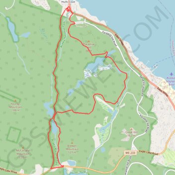
Eagle Lake to Hulls Cove Loop (Mount Desert Island)
Loop hike from Eagle Lake to Hulls Cove via Breakneck Road, Breakneck Ponds, Hulls Cove Road, Paradise Hill Carriage Road, Witch Hole Pond, Witch Hole Pond Carriage Road and Duck Brook Falls in the Acadia National Park on the Mount Desert Island. #Hiking #Loop #Lake #Nature #Forest
- Distance: 12.2 Km
- Elevation gain: 184 m
- Maximum elevation: 114 m
- Elevation loss: 183 m
- Minimum elevation: 8 m
- Moving time: 2 h 50 m
- Moving speed: 4.3 Km/h
- Maximum speed: 6.1 Km/h
- Total time: 2 h 53 m
- Global speed: 4.2 Km/h
Interactive trail map
Make a donation
Gear up for your next adventure:
As an Amazon Associate, this site earns from qualifying purchases at no extra cost to you.
Trail profile
- Distance: 12.2 Km
- Elevation gain: 184 m
- Maximum elevation: 114 m
- Elevation loss: 183 m
- Minimum elevation: 8 m
- Moving time: 2 h 50 m
- Moving speed: 4.3 Km/h
- Maximum speed: 6.1 Km/h
- Total time: 2 h 53 m
- Global speed: 4.2 Km/h
Make a donation
Gear up for your next adventure:
As an Amazon Associate, this site earns from qualifying purchases at no extra cost to you.
About this trail
Name: Eagle Lake to Hulls Cove Loop (Mount Desert Island) trail, distance, elevation, map, profile, GPS track
Start: 487, Eagle Lake Road, Bar Harbor, Hancock County, Maine, 04609, United States (44.37791 -68.25261)
End: 487, Eagle Lake Road, Bar Harbor, Hancock County, Maine, 04609, United States (44.37793 -68.25266)
Coordinates: 44.37729 -68.25736 44.41276 -68.23322
Make a donation
Gear up for your next adventure:
As an Amazon Associate, this site earns from qualifying purchases at no extra cost to you.