Thank you for supporting this site ❤️
Make a donation
Make a donation
Gear up for your next adventure:
As an Amazon Associate, this site earns from qualifying purchases at no extra cost to you.
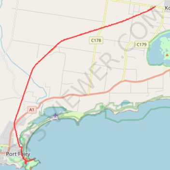
Port Fairy to Warnambool Rail Trail
#MTB
- Distance: 18.3 Km
- Elevation gain: 43 m
- Maximum elevation: 49 m
- Elevation loss: 91 m
- Minimum elevation: -1 m
Interactive trail map
Thank you for supporting this site ❤️
Make a donation
Make a donation
Gear up for your next adventure:
As an Amazon Associate, this site earns from qualifying purchases at no extra cost to you.
Trail profile
- Distance: 18.3 Km
- Elevation gain: 43 m
- Maximum elevation: 49 m
- Elevation loss: 91 m
- Minimum elevation: -1 m
Thank you for supporting this site ❤️
Make a donation
Make a donation
Gear up for your next adventure:
As an Amazon Associate, this site earns from qualifying purchases at no extra cost to you.
About this trail
Name: Port Fairy to Warnambool Rail Trail trail, distance, elevation, map, profile, GPS track
End: Battery Lane, Port Fairy, Shire of Moyne, Victoria, 3284, Australia (-38.38957 142.24964)
Coordinates: -38.39195 142.23381 -38.29018 142.35033
Topography: Victoria topographic map, elevation, terrain
Thank you for supporting this site ❤️
Make a donation
Make a donation
Gear up for your next adventure:
As an Amazon Associate, this site earns from qualifying purchases at no extra cost to you.