Connemara - Day 4
#Bike
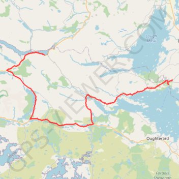
- Distance: 72.1 Km
- Elevation gain: 662 m
- Maximum elevation: 96 m
- Elevation loss: 680 m
- Minimum elevation: 0 m
Interactive trail map
Trail profile
- Distance: 72.1 Km
- Elevation gain: 662 m
- Maximum elevation: 96 m
- Elevation loss: 680 m
- Minimum elevation: 0 m
About this trail
Name: Connemara - Day 4 trail, distance, elevation, map, profile, GPS track
Coordinates: 53.45125 -9.83183 53.60006 -9.27264
Other hiking, mountain biking, running and outdoor activity trails
Click on a trail to view its statistics, map and profile.
Connemara - Day 3
#Bike
Distance: 62.5 Km • Elevation gain: 861 m • Maximum elevation: 291 m
Connemara - Day 5
Ireland > County Galway > Leenaun
#Bike
Distance: 50.3 Km • Elevation gain: 582 m • Maximum elevation: 76 m
Connemara - Day 1
Ireland > County Galway > Leenaun
#Bike
Distance: 62.2 Km • Elevation gain: 651 m • Maximum elevation: 76 m