Import a GPX file

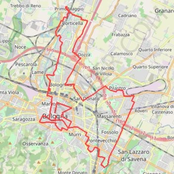
BM 24 - 42km 12_01_24

  • Distance: 42.1 Km
  • Elevation gain: 171 m
  • Maximum elevation: 80 m
  • Elevation loss: 170 m
  • Minimum elevation: 25 m

Interactive trail map

Trail profile

  • Distance: 42.1 Km
  • Elevation gain: 171 m
  • Maximum elevation: 80 m
  • Elevation loss: 170 m
  • Minimum elevation: 25 m

About this trail
Gear up for your next adventure:

🧭Global Orienteering Compass - High-precision liquid-filled compasses for accurate map reading and navigation
🔥Ferrocerium Rod Fire Starters - Reliable fire lighting in wet or windy conditions without matches
🧤Hiking Gloves - Protective gloves for outdoor use
🧤Thermal Hiking Gloves - Keep your hands warm and functional during high-altitude winter treks
🚁Camera Drones with GPS - Capture aerial views of the landscape to compare with topo maps

As an Amazon Associate, this site earns from qualifying purchases at no extra cost to you.