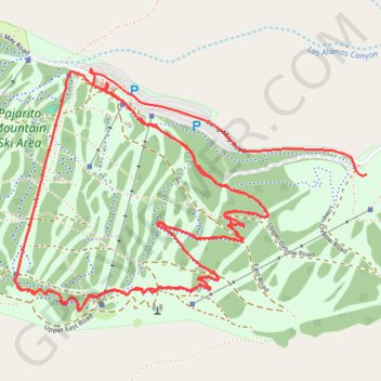
Pajarito Mountain
- Distance: 10.7 Km
- Elevation gain: 348 m
- Maximum elevation: 3,153 m
- Elevation loss: 745 m
- Minimum elevation: 2,755 m
Interactive trail map
Trail profile
- Distance: 10.7 Km
- Elevation gain: 348 m
- Maximum elevation: 3,153 m
- Elevation loss: 745 m
- Minimum elevation: 2,755 m
About this trail
Name: Pajarito Mountain trail, distance, elevation, map, profile, GPS track
Start: Aspen For Trouble, Los Alamos County, New Mexico, United States (35.88680 -106.39545)
End: Lower Aspenola, Los Alamos County, New Mexico, United States (35.89116 -106.37718)
Coordinates: 35.88540 -106.39545 35.89557 -106.37718