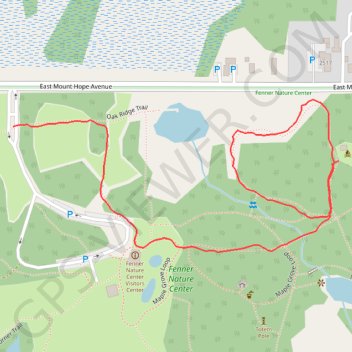
Fenner Bear Lake Extension trail
- Distance: 1.4 Km
- Elevation gain: 5 m
- Maximum elevation: 260 m
- Elevation loss: 9 m
- Minimum elevation: 252 m
- Moving time: 22 m
- Moving speed: 3.8 Km/h
- Maximum speed: 8.5 Km/h
- Total time: 22 m 52 s
- Global speed: 3.7 Km/h
Interactive trail map
Trail profile
- Distance: 1.4 Km
- Elevation gain: 5 m
- Maximum elevation: 260 m
- Elevation loss: 9 m
- Minimum elevation: 252 m
- Moving time: 22 m
- Moving speed: 3.8 Km/h
- Maximum speed: 8.5 Km/h
- Total time: 22 m 52 s
- Global speed: 3.7 Km/h
About this trail
Name: Fenner Bear Lake Extension trail trail, distance, elevation, map, profile, GPS track
Start: East Mount Hope Avenue, Lansing, Ingham County, Michigan, 48910, United States (42.71079 -84.51534)
End: Oak Ridge Trail, Lansing, Ingham County, Michigan, 48910, United States (42.71128 -84.52165)
Coordinates: 42.70949 -84.52165 42.71166 -84.51534