Gile State Forest Loop near Morgan Hill
- Distance: 8.7 Km
- Elevation gain: 194 m
- Maximum elevation: 550 m
- Elevation loss: 196 m
- Minimum elevation: 430 m
- Moving time: 2 h 24 m
- Moving speed: 3.6 Km/h
- Maximum speed: 14.7 Km/h
- Total time: 2 h 46 m
- Global speed: 3.1 Km/h
Interactive trail map
Trail profile
- Distance: 8.7 Km
- Elevation gain: 194 m
- Maximum elevation: 550 m
- Elevation loss: 196 m
- Minimum elevation: 430 m
- Moving time: 2 h 24 m
- Moving speed: 3.6 Km/h
- Maximum speed: 14.7 Km/h
- Total time: 2 h 46 m
- Global speed: 3.1 Km/h
About this trail
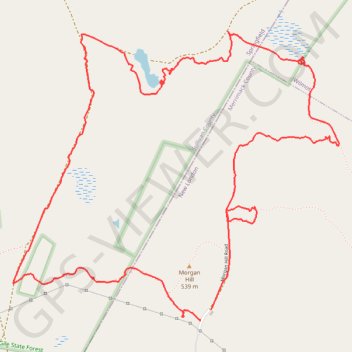
Name: Gile State Forest Loop near Morgan Hill trail, distance, elevation, map, profile, GPS track
End: Kidder Trail, New London, Merrimack County, New Hampshire, 03267, United States (43.45102 -71.99403)
Coordinates: 43.45101 -72.00775 43.46645 -71.98379
Other hiking, mountain biking, running and outdoor activity trails
Click on a trail to view its statistics, map and profile.
Kearsarge Klassic 55 from Pleasant Lake
United States > New Hampshire > Merrimack County > New London > Elkins
Around Mount Kearsarge Klassic route
Distance: 91.8 Km • Elevation gain: 1,446 m • Maximum elevation: 473 m