Make a donation
Gear up for your next adventure:
As an Amazon Associate, this site earns from qualifying purchases at no extra cost to you.
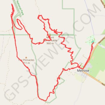
Mount Remarkable Epic MTB trail trace
2 x Laps of Melrose Epic on the single speed
- Distance: 79.8 Km
- Elevation gain: 2,980 m
- Maximum elevation: 947 m
- Elevation loss: 2,980 m
- Minimum elevation: 355 m
- Moving time: 5 h 45 m
- Moving speed: 13.9 Km/h
- Maximum speed: 20.6 Km/h
- Total time: 5 h 45 m
- Global speed: 13.9 Km/h
Interactive trail map
Make a donation
Gear up for your next adventure:
As an Amazon Associate, this site earns from qualifying purchases at no extra cost to you.
Trail profile
- Distance: 79.8 Km
- Elevation gain: 2,980 m
- Maximum elevation: 947 m
- Elevation loss: 2,980 m
- Minimum elevation: 355 m
- Moving time: 5 h 45 m
- Moving speed: 13.9 Km/h
- Maximum speed: 20.6 Km/h
- Total time: 5 h 45 m
- Global speed: 13.9 Km/h
Make a donation
Gear up for your next adventure:
As an Amazon Associate, this site earns from qualifying purchases at no extra cost to you.
About this trail
Name: Mount Remarkable Epic MTB trail trace trail, distance, elevation, map, profile, GPS track
Coordinates: -32.84426 138.13781 -32.78801 138.19497
Topography: South Australia topographic map, elevation, terrain
Make a donation
Gear up for your next adventure:
As an Amazon Associate, this site earns from qualifying purchases at no extra cost to you.
Other hiking, mountain biking, running and outdoor activity trails
Click on a trail to view its statistics, map and profile.
Sea to Summit: Spencer Gulf - Flinders Ranges - Melrose
Mount Remarkable National Park. #Hiking #Running #SeaToSummit #Remarkable
Distance: 42.6 Km • Elevation gain: 1,462 m • Maximum elevation: 950 m
Mount Remarkable North Face
Australia > South Australia > Melrose
Morning Mountain Bike Ride
Distance: 46.7 Km • Elevation gain: 1,370 m • Maximum elevation: 842 m