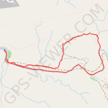
ACTIVE LOG 001
- Distance: 4.9 Km
- Elevation gain: 106 m
- Maximum elevation: 344 m
- Elevation loss: 105 m
- Minimum elevation: 298 m
- Moving time: 1 h 34 m
- Moving speed: 3.1 Km/h
- Maximum speed: 4.7 Km/h
- Total time: 2 h 12 m
- Global speed: 2.2 Km/h
Interactive trail map
Trail profile
- Distance: 4.9 Km
- Elevation gain: 106 m
- Maximum elevation: 344 m
- Elevation loss: 105 m
- Minimum elevation: 298 m
- Moving time: 1 h 34 m
- Moving speed: 3.1 Km/h
- Maximum speed: 4.7 Km/h
- Total time: 2 h 12 m
- Global speed: 2.2 Km/h
About this trail
Name: ACTIVE LOG 001 trail, distance, elevation, map, profile, GPS track
Start: Sharjah - Kalba Road, Ras al-Khaimah, United Arab Emirates (25.10516 56.04608)
End: Sharjah - Kalba Road, Ras al-Khaimah, United Arab Emirates (25.10517 56.04612)
Coordinates: 25.10151 56.04607 25.10757 56.06218