Thank you for supporting this site ❤️
Make a donation
Make a donation
Gear up for your next adventure:
As an Amazon Associate, this site earns from qualifying purchases at no extra cost to you.
Minnekhada Regional Park
#Hiking #Loop #Minnekhada
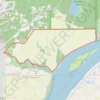
- Distance: 8.3 Km
- Elevation gain: 46 m
- Maximum elevation: 13 m
- Elevation loss: 45 m
- Minimum elevation: 1 m
Interactive trail map
Thank you for supporting this site ❤️
Make a donation
Make a donation
Gear up for your next adventure:
As an Amazon Associate, this site earns from qualifying purchases at no extra cost to you.
Trail profile
- Distance: 8.3 Km
- Elevation gain: 46 m
- Maximum elevation: 13 m
- Elevation loss: 45 m
- Minimum elevation: 1 m
Thank you for supporting this site ❤️
Make a donation
Make a donation
Gear up for your next adventure:
As an Amazon Associate, this site earns from qualifying purchases at no extra cost to you.
About this trail
Name: Minnekhada Regional Park trail, distance, elevation, map, profile, GPS track
Coordinates: 49.27974 -122.73392 49.29320 -122.68906
Thank you for supporting this site ❤️
Make a donation
Make a donation
Gear up for your next adventure:
🧭Military Style Lensatic Compass - Durable sighting compasses for advanced land navigation and surveying
As an Amazon Associate, this site earns from qualifying purchases at no extra cost to you.
Other hiking, mountain biking, running and outdoor activity trails
Click on a trail to view its statistics, map and profile.