Import a GPX file

Jodrey Trail and Woodland Trail loop hike in Blomidon Provincial Park

  • Distance: 7.7 Km
  • Elevation gain: 180 m
  • Maximum elevation: 206 m
  • Elevation loss: 179 m
  • Minimum elevation: 142 m
  • Moving time: 2 h 1 m
  • Moving speed: 3.8 Km/h
  • Maximum speed: 8.2 Km/h
  • Total time: 2 h 20 m
  • Global speed: 3.3 Km/h

Interactive trail map

Trail profile

  • Distance: 7.7 Km
  • Elevation gain: 180 m
  • Maximum elevation: 206 m
  • Elevation loss: 179 m
  • Minimum elevation: 142 m
  • Moving time: 2 h 1 m
  • Moving speed: 3.8 Km/h
  • Maximum speed: 8.2 Km/h
  • Total time: 2 h 20 m
  • Global speed: 3.3 Km/h

About this trail
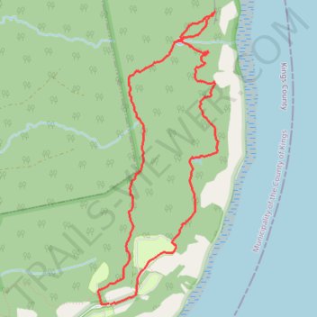
Name: Jodrey Trail and Woodland Trail loop hike in Blomidon Provincial Park trail, distance, elevation, map, profile, GPS track

Start: Pereau Road, Blomidon Provincial Park, Municipality of the County of Kings, Kings County, Nova Scotia, B0P 1H0, Canada (45.26408 -64.34132)

End: Pereau Road, Blomidon Provincial Park, Municipality of the County of Kings, Kings County, Nova Scotia, B0P 1H0, Canada (45.26413 -64.34148)

Coordinates: 45.26405 -64.34271 45.28704 -64.32928

Gear up for your next adventure:

🔑Heavy Duty Carabiners - Secure gear to the outside of your pack for easy access
🥾Hiking Shoes - Lightweight hiking shoes for day hikes
🦯Trekking Poles - Walking poles for hiking stability
🧊Insulated Stainless Steel Flasks - Keep water cold for 24 hours in the heat or coffee hot in the cold
🧥Down Jackets - Insulated jackets for cold weather

As an Amazon Associate, this site earns from qualifying purchases at no extra cost to you.