Thank you for supporting this site ❤️
Make a donation
Make a donation
Gear up for your next adventure:
As an Amazon Associate, this site earns from qualifying purchases at no extra cost to you.
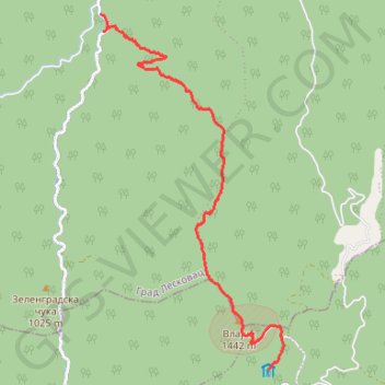
7-9-10 Staza br.10 Vlajna
- Distance: 8.7 Km
- Elevation gain: 213 m
- Maximum elevation: 1,439 m
- Elevation loss: 904 m
- Minimum elevation: 569 m
- Moving time: 2 h 16 m
- Moving speed: 3.8 Km/h
- Maximum speed: 5.7 Km/h
- Total time: 3 h 41 m
- Global speed: 2.3 Km/h
Interactive trail map
Thank you for supporting this site ❤️
Make a donation
Make a donation
Gear up for your next adventure:
As an Amazon Associate, this site earns from qualifying purchases at no extra cost to you.
Trail profile
- Distance: 8.7 Km
- Elevation gain: 213 m
- Maximum elevation: 1,439 m
- Elevation loss: 904 m
- Minimum elevation: 569 m
- Moving time: 2 h 16 m
- Moving speed: 3.8 Km/h
- Maximum speed: 5.7 Km/h
- Total time: 3 h 41 m
- Global speed: 2.3 Km/h
Thank you for supporting this site ❤️
Make a donation
Make a donation
Gear up for your next adventure:
As an Amazon Associate, this site earns from qualifying purchases at no extra cost to you.
About this trail
Name: 7-9-10 Staza br.10 Vlajna trail, distance, elevation, map, profile, GPS track
Coordinates: 42.78496 21.92270 42.82988 21.95428
Thank you for supporting this site ❤️
Make a donation
Make a donation
Gear up for your next adventure:
As an Amazon Associate, this site earns from qualifying purchases at no extra cost to you.
Other hiking, mountain biking, running and outdoor activity trails
Click on a trail to view its statistics, map and profile.
2022_Yu
Slovenia > Ajdovščina > Žapuže
Distance: 2,457.3 Km • Elevation gain: 32,048 m • Maximum elevation: 1,950 m