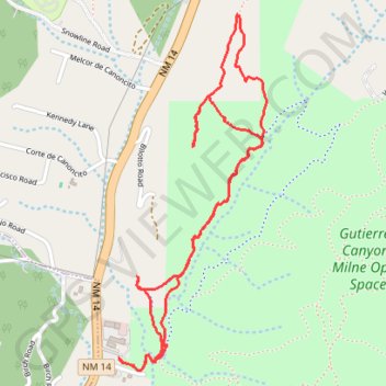
Guttierez Canyon-Milne Open Space Hike
- Distance: 5.0 Km
- Elevation gain: 136 m
- Maximum elevation: 2,174 m
- Elevation loss: 136 m
- Minimum elevation: 2,070 m
- Moving time: 1 h 24 m
- Moving speed: 3.5 Km/h
- Maximum speed: 6.1 Km/h
- Total time: 1 h 34 m
- Global speed: 3.1 Km/h
Interactive trail map
Trail profile
- Distance: 5.0 Km
- Elevation gain: 136 m
- Maximum elevation: 2,174 m
- Elevation loss: 136 m
- Minimum elevation: 2,070 m
- Moving time: 1 h 24 m
- Moving speed: 3.5 Km/h
- Maximum speed: 6.1 Km/h
- Total time: 1 h 34 m
- Global speed: 3.1 Km/h
About this trail
Name: Guttierez Canyon-Milne Open Space Hike trail, distance, elevation, map, profile, GPS track
Coordinates: 35.12892 -106.36537 35.14218 -106.35861
Other hiking, mountain biking, running and outdoor activity trails
Click on a trail to view its statistics, map and profile.
Gutierrez Canyon-Milne Open Space loop
United States > New Mexico > Bernalillo County > Sierra Vista Estates
Distance: 7.3 Km • Elevation gain: 238 m • Maximum elevation: 2,162 m
Gutierrez Canyon-Milne Open Space
United States > New Mexico > Bernalillo County > Sandia Haven
Distance: 10.8 Km • Elevation gain: 299 m • Maximum elevation: 2,177 m