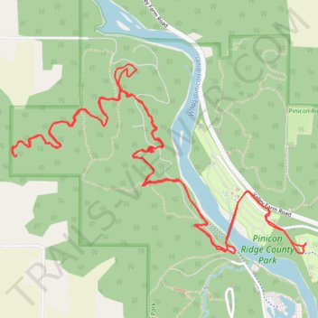
Riverline and Echo Bench ride
- Distance: 9.3 Km
- Elevation gain: 187 m
- Maximum elevation: 297 m
- Elevation loss: 188 m
- Minimum elevation: 255 m
- Moving time: 42 m 40 s
- Moving speed: 13.0 Km/h
- Maximum speed: 35.9 Km/h
- Total time: 46 m 13 s
- Global speed: 12.0 Km/h
Interactive trail map
Trail profile
- Distance: 9.3 Km
- Elevation gain: 187 m
- Maximum elevation: 297 m
- Elevation loss: 188 m
- Minimum elevation: 255 m
- Moving time: 42 m 40 s
- Moving speed: 13.0 Km/h
- Maximum speed: 35.9 Km/h
- Total time: 46 m 13 s
- Global speed: 12.0 Km/h
About this trail
Name: Riverline and Echo Bench ride trail, distance, elevation, map, profile, GPS track
Coordinates: 42.21617 -91.55858 42.22604 -91.53784
Other hiking, mountain biking, running and outdoor activity trails
Click on a trail to view its statistics, map and profile.
Deep Woods - Mountain Bike Ride in Pinicon Ridge County Park
United States > Iowa > Linn County
Distance: 3.2 Km • Elevation gain: 65 m • Maximum elevation: 291 m
Pinicon Ridge County Park trails
United States > Iowa > Linn County
Distance: 7.2 Km • Elevation gain: 156 m • Maximum elevation: 305 m
Pinicon Ridge County Park
United States > Iowa > Linn County
Distance: 9.6 Km • Elevation gain: 193 m • Maximum elevation: 299 m