Thank you for supporting this site ❤️
Make a donation
Make a donation
Gear up for your next adventure:
As an Amazon Associate, this site earns from qualifying purchases at no extra cost to you.
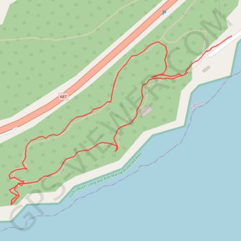
Woodland loop walk Balmacara
- Distance: 1.3 Km
- Elevation gain: 48 m
- Maximum elevation: 42 m
- Elevation loss: 55 m
- Minimum elevation: 8 m
- Moving time: 24 m 29 s
- Moving speed: 3.1 Km/h
- Maximum speed: 8.3 Km/h
- Total time: 28 m 18 s
- Global speed: 2.7 Km/h
Interactive trail map
Thank you for supporting this site ❤️
Make a donation
Make a donation
Gear up for your next adventure:
As an Amazon Associate, this site earns from qualifying purchases at no extra cost to you.
Trail profile
- Distance: 1.3 Km
- Elevation gain: 48 m
- Maximum elevation: 42 m
- Elevation loss: 55 m
- Minimum elevation: 8 m
- Moving time: 24 m 29 s
- Moving speed: 3.1 Km/h
- Maximum speed: 8.3 Km/h
- Total time: 28 m 18 s
- Global speed: 2.7 Km/h
Thank you for supporting this site ❤️
Make a donation
Make a donation
Gear up for your next adventure:
As an Amazon Associate, this site earns from qualifying purchases at no extra cost to you.
About this trail
Name: Woodland loop walk Balmacara trail, distance, elevation, map, profile, GPS track
Start: Glaick, Balmacara, Highland, Scotland, IV40 8DN, United Kingdom (57.28378 -5.65821)
End: Glaick, Balmacara, Highland, Scotland, IV40 8DN, United Kingdom (57.28435 -5.65692)
Coordinates: 57.28166 -5.66349 57.28435 -5.65692
Thank you for supporting this site ❤️
Make a donation
Make a donation
Gear up for your next adventure:
As an Amazon Associate, this site earns from qualifying purchases at no extra cost to you.