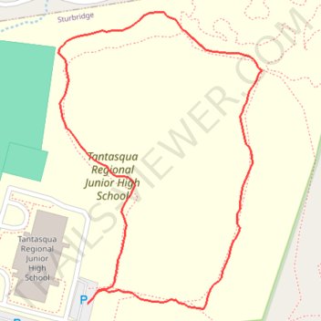
The "Warriors Way" trail at Tantasqua Trails
Tantasqua, Sturbridge, Massachusetts
- Distance: 1.1 Km
- Elevation gain: 17 m
- Maximum elevation: 231 m
- Elevation loss: 18 m
- Minimum elevation: 217 m
- Moving time: 17 m 55 s
- Moving speed: 3.8 Km/h
- Maximum speed: 10.8 Km/h
- Total time: 18 m 33 s
- Global speed: 3.6 Km/h
Interactive trail map
Trail profile
- Distance: 1.1 Km
- Elevation gain: 17 m
- Maximum elevation: 231 m
- Elevation loss: 18 m
- Minimum elevation: 217 m
- Moving time: 17 m 55 s
- Moving speed: 3.8 Km/h
- Maximum speed: 10.8 Km/h
- Total time: 18 m 33 s
- Global speed: 3.6 Km/h
About this trail
Name: The "Warriors Way" trail at Tantasqua Trails trail, distance, elevation, map, profile, GPS track
End: Pond Loop, Sturbridge, Worcester County, Massachusetts, 01518, United States (42.15957 -72.12617)
Coordinates: 42.15952 -72.12660 42.16274 -72.12362