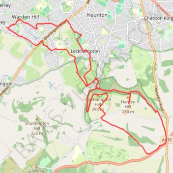
Cheltenham Seven Springs Loop Walking
- Distance: 19.1 Km
- Elevation gain: 402 m
- Maximum elevation: 292 m
- Elevation loss: 403 m
- Minimum elevation: 55 m
Interactive trail map
Trail profile
- Distance: 19.1 Km
- Elevation gain: 402 m
- Maximum elevation: 292 m
- Elevation loss: 403 m
- Minimum elevation: 55 m
About this trail
Name: Cheltenham Seven Springs Loop Walking trail, distance, elevation, map, profile, GPS track
Coordinates: 51.84909 -2.11387 51.88364 -2.04753
Other hiking, mountain biking, running and outdoor activity trails
Click on a trail to view its statistics, map and profile.
Dean2023-311
United Kingdom > England > Oxfordshire > Oxford
Distance: 310.3 Km • Elevation gain: 3,366 m • Maximum elevation: 290 m