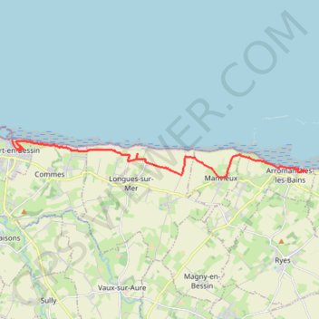
Arromanches PortenBessin
- Distance: 13.9 Km
- Elevation gain: 197 m
- Maximum elevation: 74 m
- Elevation loss: 239 m
- Minimum elevation: 0 m
Interactive trail map
Trail profile
- Distance: 13.9 Km
- Elevation gain: 197 m
- Maximum elevation: 74 m
- Elevation loss: 239 m
- Minimum elevation: 0 m
About this trail
Name: Arromanches PortenBessin trail, distance, elevation, map, profile, GPS track
Coordinates: 49.33746 -0.75415 49.34874 -0.61457
Other hiking, mountain biking, running and outdoor activity trails
Click on a trail to view its statistics, map and profile.
Bayeux boucle ouest longue
France > Normandy > Calvados > Bayeux
Distance: 74.6 Km • Elevation gain: 547 m • Maximum elevation: 76 m
PortEnBessin-Bayeux
France > Normandy > Calvados > Port-en-Bessin-Huppain
Distance: 17.5 Km • Elevation gain: 156 m • Maximum elevation: 67 m
Bayeux-Caen short
France > Normandy > Calvados > Bayeux
Distance: 52.4 Km • Elevation gain: 405 m • Maximum elevation: 77 m
Bayeux-Caen Long
France > Normandy > Calvados > Bayeux
Distance: 64.2 Km • Elevation gain: 458 m • Maximum elevation: 77 m
Bayeux Boucle ouest courte
France > Normandy > Calvados > Bayeux
Distance: 56.8 Km • Elevation gain: 440 m • Maximum elevation: 76 m
Bayeux East short loop
France > Normandy > Calvados > Bayeux
Distance: 28.1 Km • Elevation gain: 223 m • Maximum elevation: 74 m