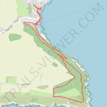
Loop Walk from Cawsand, Cornwall
- Distance: 6.2 Km
- Elevation gain: 188 m
- Maximum elevation: 107 m
- Elevation loss: 189 m
- Minimum elevation: 4 m
- Moving time: 1 h 49 m
- Moving speed: 3.4 Km/h
- Maximum speed: 6.8 Km/h
- Total time: 3 h 2 m
- Global speed: 2.0 Km/h
Interactive trail map
Trail profile
- Distance: 6.2 Km
- Elevation gain: 188 m
- Maximum elevation: 107 m
- Elevation loss: 189 m
- Minimum elevation: 4 m
- Moving time: 1 h 49 m
- Moving speed: 3.4 Km/h
- Maximum speed: 6.8 Km/h
- Total time: 3 h 2 m
- Global speed: 2.0 Km/h
About this trail
Name: Loop Walk from Cawsand, Cornwall trail, distance, elevation, map, profile, GPS track
Coordinates: 50.31860 -4.20505 50.33411 -4.19027
Other hiking, mountain biking, running and outdoor activity trails
Click on a trail to view its statistics, map and profile.
Cawsand, Anthony, Torpoint
United Kingdom > England > Cornwall > Cawsand
Distance: 16.3 Km • Elevation gain: 397 m • Maximum elevation: 113 m
Mount Edgcumbe
United Kingdom > England > Plymouth
Distance: 14.4 Km • Elevation gain: 348 m • Maximum elevation: 91 m