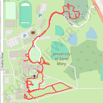
University of Saint Mary
- Distance: 3.8 Km
- Elevation gain: 40 m
- Maximum elevation: 286 m
- Elevation loss: 36 m
- Minimum elevation: 269 m
- Moving time: 1 h 2 m
- Moving speed: 3.6 Km/h
- Maximum speed: 6.3 Km/h
- Total time: 1 h 29 m
- Global speed: 2.5 Km/h
Interactive trail map
Trail profile
- Distance: 3.8 Km
- Elevation gain: 40 m
- Maximum elevation: 286 m
- Elevation loss: 36 m
- Minimum elevation: 269 m
- Moving time: 1 h 2 m
- Moving speed: 3.6 Km/h
- Maximum speed: 6.3 Km/h
- Total time: 1 h 29 m
- Global speed: 2.5 Km/h
About this trail
Name: University of Saint Mary trail, distance, elevation, map, profile, GPS track
Coordinates: 39.27543 -94.90743 39.28118 -94.90307