Import a GPX file

Falcons Lookout via Ironbark Gorge Track in Werribee Gorge State Park

  • Distance: 4.0 Km
  • Elevation gain: 213 m
  • Maximum elevation: 397 m
  • Elevation loss: 212 m
  • Minimum elevation: 305 m

Interactive trail map

Trail profile

  • Distance: 4.0 Km
  • Elevation gain: 213 m
  • Maximum elevation: 397 m
  • Elevation loss: 212 m
  • Minimum elevation: 305 m

About this trail
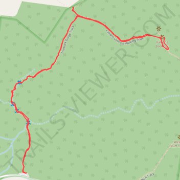
Name: Falcons Lookout via Ironbark Gorge Track in Werribee Gorge State Park trail, distance, elevation, map, profile, GPS track

Start: Ironbark Gorge Trailhead, Ironbark Gorge Track, Ingliston, Victoria, 3342, Australia (-37.66558 144.33451)

End: Ironbark Gorge Trailhead, Ironbark Gorge Track, Ingliston, Victoria, 3342, Australia (-37.66558 144.33437)

Coordinates: -37.66559 144.33351 -37.65708 144.34368

Topography: Victoria topographic map, elevation, terrain

Gear up for your next adventure:

🧺Fast-Dry Microfiber Towels - Large towels that pack down to the size of an orange
🩹First Aid Kits - Emergency kits for hiking
⛺Ultralight Solo Tents - Compact shelters for multi-day topographic surveying expeditions
🧤Thermal Hiking Gloves - Keep your hands warm and functional during high-altitude winter treks
📡Portable Emergency Radios - Stay informed about weather warnings and bushfire alerts

As an Amazon Associate, this site earns from qualifying purchases at no extra cost to you.