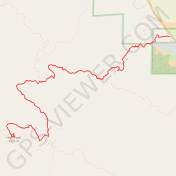
Import a GPX file

High Point

Hike to High Point Lookout from Oak Grove via Oak Grove Trail in Cleveland National Forest. #Hiking #Mountain #Nature #Forest

  • Distance: 10.7 Km
  • Elevation gain: 1,103 m
  • Maximum elevation: 1,867 m
  • Elevation loss: 80 m
  • Minimum elevation: 837 m

Interactive trail map

Trail profile

  • Distance: 10.7 Km
  • Elevation gain: 1,103 m
  • Maximum elevation: 1,867 m
  • Elevation loss: 80 m
  • Minimum elevation: 837 m

About this trail

Name: High Point trail, distance, elevation, map, profile, GPS track

Start: Oak Grove Trail, Oak Grove, San Diego County, California, United States (33.38634 -116.79203)

End: High Point Lookout Road, San Diego County, California, United States (33.36337 -116.83647)

Coordinates: 33.36155 -116.83840 33.38666 -116.79203

Gear up for your next adventure:

🧢Outdoor Sun Hats - Sun protection hats for hiking
Lightweight Tents - Compact tents for backpacking
🧢Wide Brim Sun Hats - Maximum coverage for the face and neck while out in the open
📍Handheld GPS - GPS devices for hiking and navigation
🧊Insulated Stainless Steel Flasks - Keep water cold for 24 hours in the heat or coffee hot in the cold

As an Amazon Associate, this site earns from qualifying purchases at no extra cost to you.