Thank you for supporting this site ❤️
Make a donation
Make a donation
Gear up for your next adventure:
As an Amazon Associate, this site earns from qualifying purchases at no extra cost to you.
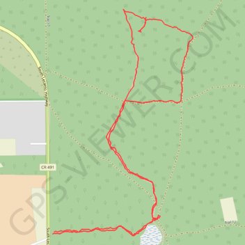
Big Hammock
Loop hike to Big Hammock via Mansfield Pond in the Withlacoochee State Forest and the Citrus Wildlife Management Area. #Hiking #Loop #Nature #Forest #Lake
- Distance: 5.1 Km
- Elevation gain: 42 m
- Maximum elevation: 28 m
- Elevation loss: 42 m
- Minimum elevation: 4 m
- Moving time: 1 h 34 m
- Moving speed: 3.2 Km/h
- Maximum speed: 6.9 Km/h
- Total time: 2 h 10 m
- Global speed: 2.3 Km/h
Interactive trail map
Thank you for supporting this site ❤️
Make a donation
Make a donation
Gear up for your next adventure:
As an Amazon Associate, this site earns from qualifying purchases at no extra cost to you.
Trail profile
- Distance: 5.1 Km
- Elevation gain: 42 m
- Maximum elevation: 28 m
- Elevation loss: 42 m
- Minimum elevation: 4 m
- Moving time: 1 h 34 m
- Moving speed: 3.2 Km/h
- Maximum speed: 6.9 Km/h
- Total time: 2 h 10 m
- Global speed: 2.3 Km/h
Thank you for supporting this site ❤️
Make a donation
Make a donation
Gear up for your next adventure:
As an Amazon Associate, this site earns from qualifying purchases at no extra cost to you.
About this trail
Name: Big Hammock trail, distance, elevation, map, profile, GPS track
Coordinates: 28.78350 -82.45034 28.79500 -82.44222
Thank you for supporting this site ❤️
Make a donation
Make a donation
Gear up for your next adventure:
As an Amazon Associate, this site earns from qualifying purchases at no extra cost to you.