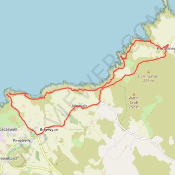
Pendeen to Porthmeor
- Distance: 17.6 Km
- Elevation gain: 578 m
- Maximum elevation: 140 m
- Elevation loss: 588 m
- Minimum elevation: 0 m
- Moving time: 4 h 43 m
- Moving speed: 3.7 Km/h
- Maximum speed: 22.3 Km/h
- Total time: 6 h 3 m
- Global speed: 2.9 Km/h
Interactive trail map
Trail profile
- Distance: 17.6 Km
- Elevation gain: 578 m
- Maximum elevation: 140 m
- Elevation loss: 588 m
- Minimum elevation: 0 m
- Moving time: 4 h 43 m
- Moving speed: 3.7 Km/h
- Maximum speed: 22.3 Km/h
- Total time: 6 h 3 m
- Global speed: 2.9 Km/h
About this trail
Name: Pendeen to Porthmeor trail, distance, elevation, map, profile, GPS track
Start: Boscaswell, St Just, Cornwall, England, TR19 7ED, United Kingdom (50.16486 -5.67033)
Coordinates: 50.15282 -5.67213 50.18094 -5.59759
Other hiking, mountain biking, running and outdoor activity trails
Click on a trail to view its statistics, map and profile.
Porthmeor Zennor Loop Hike
United Kingdom > England > Cornwall > Porthmeor > Treen
Distance: 14.8 Km • Elevation gain: 634 m • Maximum elevation: 125 m
Boscaswell, St Just
United Kingdom > England > Cornwall > St Just > Bollowall
Distance: 18.2 Km • Elevation gain: 540 m • Maximum elevation: 139 m