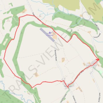
Gillamoor loop walk
- Distance: 8.8 Km
- Elevation gain: 185 m
- Maximum elevation: 212 m
- Elevation loss: 185 m
- Minimum elevation: 121 m
- Moving time: 2 h 25 m
- Moving speed: 3.6 Km/h
- Maximum speed: 5.6 Km/h
- Total time: 2 h 48 m
- Global speed: 3.1 Km/h
Interactive trail map
Trail profile
- Distance: 8.8 Km
- Elevation gain: 185 m
- Maximum elevation: 212 m
- Elevation loss: 185 m
- Minimum elevation: 121 m
- Moving time: 2 h 25 m
- Moving speed: 3.6 Km/h
- Maximum speed: 5.6 Km/h
- Total time: 2 h 48 m
- Global speed: 3.1 Km/h
About this trail
Name: Gillamoor loop walk trail, distance, elevation, map, profile, GPS track
Coordinates: 54.29485 -0.99321 54.31440 -0.94972
Other hiking, mountain biking, running and outdoor activity trails
Click on a trail to view its statistics, map and profile.
Lastingham MTB Loop
United Kingdom > England > North Yorkshire > Lastingham
Distance: 44.2 Km • Elevation gain: 1,046 m • Maximum elevation: 370 m
Gillamoor MTB Loop
United Kingdom > England > North Yorkshire > Gillamoor
Distance: 14.2 Km • Elevation gain: 374 m • Maximum elevation: 314 m
St Gregory's loop
United Kingdom > England > North Yorkshire > Helmsley
Distance: 30.5 Km • Elevation gain: 525 m • Maximum elevation: 294 m
Farndale
United Kingdom > England > North Yorkshire > Appleton-le-Moors
Ryedale Mountain Biking
Distance: 52.9 Km • Elevation gain: 1,251 m • Maximum elevation: 407 m