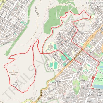
Signal Hill and Lions Head
- Distance: 11.1 Km
- Elevation gain: 471 m
- Maximum elevation: 464 m
- Elevation loss: 499 m
- Minimum elevation: 51 m
- Moving time: 1 h 43 m
- Moving speed: 6.5 Km/h
- Maximum speed: 20.1 Km/h
- Total time: 1 h 43 m
- Global speed: 6.5 Km/h
Interactive trail map
Trail profile
- Distance: 11.1 Km
- Elevation gain: 471 m
- Maximum elevation: 464 m
- Elevation loss: 499 m
- Minimum elevation: 51 m
- Moving time: 1 h 43 m
- Moving speed: 6.5 Km/h
- Maximum speed: 20.1 Km/h
- Total time: 1 h 43 m
- Global speed: 6.5 Km/h
About this trail
Name: Signal Hill and Lions Head trail, distance, elevation, map, profile, GPS track
Coordinates: -33.93996 18.38658 -33.92154 18.41207
Other hiking, mountain biking, running and outdoor activity trails
Click on a trail to view its statistics, map and profile.
Simon's Town - Cape Town
South Africa > Western Cape > City of Cape Town > Simon's Town
#Bike
Distance: 53.9 Km • Elevation gain: 1,127 m • Maximum elevation: 184 m
Cape Town - Gun Run Trail 2023
South Africa > Western Cape > City of Cape Town > Cape Town
Distance: 17.4 Km • Elevation gain: 710 m • Maximum elevation: 521 m