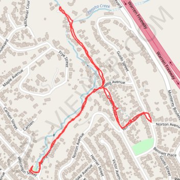
Peralta Creek / Rettig Canyon Walk
Oakland Walking
- Distance: 2.8 Km
- Elevation gain: 77 m
- Maximum elevation: 136 m
- Elevation loss: 80 m
- Minimum elevation: 82 m
- Moving time: 41 m 10 s
- Moving speed: 4.1 Km/h
- Maximum speed: 10.2 Km/h
- Total time: 44 m 27 s
- Global speed: 3.8 Km/h
Interactive trail map
Trail profile
- Distance: 2.8 Km
- Elevation gain: 77 m
- Maximum elevation: 136 m
- Elevation loss: 80 m
- Minimum elevation: 82 m
- Moving time: 41 m 10 s
- Moving speed: 4.1 Km/h
- Maximum speed: 10.2 Km/h
- Total time: 44 m 27 s
- Global speed: 3.8 Km/h
About this trail
Name: Peralta Creek / Rettig Canyon Walk trail, distance, elevation, map, profile, GPS track
Start: 4101, Rettig Place, Oakland, Alameda County, California, 94602, United States (37.79954 -122.19792)
Coordinates: 37.79943 -122.19792 37.80610 -122.19173