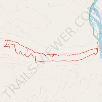
Antler trail
- Distance: 15.8 Km
- Elevation gain: 570 m
- Maximum elevation: 1,261 m
- Elevation loss: 570 m
- Minimum elevation: 954 m
- Moving time: 2 h 32 m
- Moving speed: 6.2 Km/h
- Maximum speed: 35.0 Km/h
- Total time: 2 h 52 m
- Global speed: 5.5 Km/h
Interactive trail map
Trail profile
- Distance: 15.8 Km
- Elevation gain: 570 m
- Maximum elevation: 1,261 m
- Elevation loss: 570 m
- Minimum elevation: 954 m
- Moving time: 2 h 32 m
- Moving speed: 6.2 Km/h
- Maximum speed: 35.0 Km/h
- Total time: 2 h 52 m
- Global speed: 5.5 Km/h
About this trail
Name: Antler trail trail, distance, elevation, map, profile, GPS track
Start: Southside Road, Missoula County, Montana, United States (46.96706 -114.23100)
End: Southside Road, Missoula County, Montana, United States (46.96703 -114.23098)
Coordinates: 46.96418 -114.28475 46.97325 -114.22899