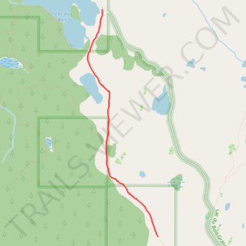
Wheeler Mountain Road Trail South of Lac du Bois
- Distance: 3.1 Km
- Elevation gain: 43 m
- Maximum elevation: 923 m
- Elevation loss: 30 m
- Minimum elevation: 879 m
- Moving time: 54 m 4 s
- Moving speed: 3.4 Km/h
- Maximum speed: 8.6 Km/h
- Total time: 1 h 3 m
- Global speed: 2.9 Km/h
Interactive trail map
Trail profile
- Distance: 3.1 Km
- Elevation gain: 43 m
- Maximum elevation: 923 m
- Elevation loss: 30 m
- Minimum elevation: 879 m
- Moving time: 54 m 4 s
- Moving speed: 3.4 Km/h
- Maximum speed: 8.6 Km/h
- Total time: 1 h 3 m
- Global speed: 2.9 Km/h
About this trail
Name: Wheeler Mountain Road Trail South of Lac du Bois trail, distance, elevation, map, profile, GPS track
Coordinates: 50.77385 -120.45311 50.79828 -120.44120
Other hiking, mountain biking, running and outdoor activity trails
Click on a trail to view its statistics, map and profile.
Lac du Bois Grasslands Protected Area
Canada > British Columbia > Thompson-Nicola Regional District > Area J (Copper Desert Country)
#Hiking #Snowshoeing #Loop #LacDuBois
Distance: 3.9 Km • Elevation gain: 135 m • Maximum elevation: 924 m
Cache Creek - Kamloops
Canada > British Columbia > Thompson-Nicola Regional District > Cache Creek
Distance: 86.9 Km • Elevation gain: 1,114 m • Maximum elevation: 736 m