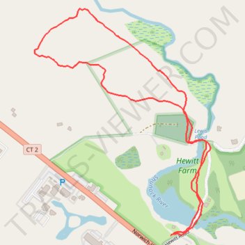
Thank you for supporting this site ❤️
Make a donation
Make a donation
Gear up for your next adventure:
As an Amazon Associate, this site earns from qualifying purchases at no extra cost to you.
Hewitt Farm Trails
- Distance: 2.5 Km
- Elevation gain: 47 m
- Maximum elevation: 83 m
- Elevation loss: 47 m
- Minimum elevation: 44 m
- Moving time: 42 m 2 s
- Moving speed: 3.6 Km/h
- Maximum speed: 5.7 Km/h
- Total time: 57 m 39 s
- Global speed: 2.6 Km/h
Interactive trail map
Thank you for supporting this site ❤️
Make a donation
Make a donation
Gear up for your next adventure:
As an Amazon Associate, this site earns from qualifying purchases at no extra cost to you.
Trail profile
- Distance: 2.5 Km
- Elevation gain: 47 m
- Maximum elevation: 83 m
- Elevation loss: 47 m
- Minimum elevation: 44 m
- Moving time: 42 m 2 s
- Moving speed: 3.6 Km/h
- Maximum speed: 5.7 Km/h
- Total time: 57 m 39 s
- Global speed: 2.6 Km/h
Thank you for supporting this site ❤️
Make a donation
Make a donation
Gear up for your next adventure:
⌚Altimeter Barometer Watches - Outdoor watches with built-in sensors to track altitude changes and weather shifts
As an Amazon Associate, this site earns from qualifying purchases at no extra cost to you.
About this trail
Name: Hewitt Farm Trails trail, distance, elevation, map, profile, GPS track
Coordinates: 41.44648 -71.89802 41.45326 -71.89100
Thank you for supporting this site ❤️
Make a donation
Make a donation
Gear up for your next adventure:
As an Amazon Associate, this site earns from qualifying purchases at no extra cost to you.