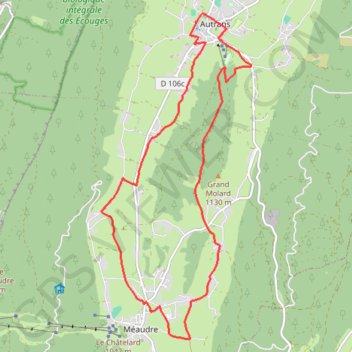
B12 A la découverte des deux villages, départ Autr
- Distance: 16.2 Km
- Elevation gain: 344 m
- Maximum elevation: 1,193 m
- Elevation loss: 344 m
- Minimum elevation: 968 m
- Moving time: 56 m 32 s
- Moving speed: 17.2 Km/h
- Maximum speed: 22.1 Km/h
- Total time: 56 m 32 s
- Global speed: 17.2 Km/h
Interactive trail map
Trail profile
- Distance: 16.2 Km
- Elevation gain: 344 m
- Maximum elevation: 1,193 m
- Elevation loss: 344 m
- Minimum elevation: 968 m
- Moving time: 56 m 32 s
- Moving speed: 17.2 Km/h
- Maximum speed: 22.1 Km/h
- Total time: 56 m 32 s
- Global speed: 17.2 Km/h
About this trail
Name: B12 A la découverte des deux villages, départ Autr trail, distance, elevation, map, profile, GPS track
Coordinates: 45.12525 5.51816 45.17770 5.55246
Other hiking, mountain biking, running and outdoor activity trails
Click on a trail to view its statistics, map and profile.
Chemin de Saint-Jacques-de-Compostelle
Switzerland > Geneva > Geneva
Distance: 1,117.8 Km • Elevation gain: 25,262 m • Maximum elevation: 1,430 m
PT23DS2 Lörrach → Cadaqués
Germany > Baden-Württemberg > Landkreis Lörrach > Lörrach (Kernstadt)
Distance: 1,050.7 Km • Elevation gain: 13,130 m • Maximum elevation: 1,505 m