Parade Ground loops
- Distance: 4.5 Km
- Elevation gain: 34 m
- Maximum elevation: 212 m
- Elevation loss: 34 m
- Minimum elevation: 194 m
- Moving time: 54 m 17 s
- Moving speed: 5.0 Km/h
- Maximum speed: 6.8 Km/h
- Total time: 54 m 17 s
- Global speed: 5.0 Km/h
Interactive trail map
Trail profile
- Distance: 4.5 Km
- Elevation gain: 34 m
- Maximum elevation: 212 m
- Elevation loss: 34 m
- Minimum elevation: 194 m
- Moving time: 54 m 17 s
- Moving speed: 5.0 Km/h
- Maximum speed: 6.8 Km/h
- Total time: 54 m 17 s
- Global speed: 5.0 Km/h
About this trail
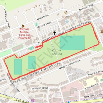
Name: Parade Ground loops trail, distance, elevation, map, profile, GPS track
Coordinates: 15.17814 120.51846 15.18283 120.52661