Import a GPX file

Run from Skelton Lake to Hollinthorpe and back via the north of Swillington

Uncharted territory

  • Distance: 15.5 Km
  • Elevation gain: 151 m
  • Maximum elevation: 90 m
  • Elevation loss: 150 m
  • Minimum elevation: 14 m

Interactive trail map

Trail profile

  • Distance: 15.5 Km
  • Elevation gain: 151 m
  • Maximum elevation: 90 m
  • Elevation loss: 150 m
  • Minimum elevation: 14 m

About this trail
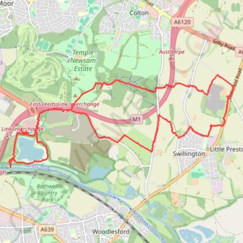
Name: Run from Skelton Lake to Hollinthorpe and back via the north of Swillington trail, distance, elevation, map, profile, GPS track

Start: Skelton Lake Service Station, Lakeside Way, Rothwell, West Yorkshire, England, LS9 0AS, United Kingdom (53.77280 -1.47388)

End: Skelton Lake Service Station, Lakeside Way Roundabout, Rothwell, West Yorkshire, England, LS9 0AS, United Kingdom (53.77288 -1.47361)

Coordinates: 53.76590 -1.47761 53.78250 -1.40938

Other hiking, mountain biking, running and outdoor activity trails

Click on a trail to view its statistics, map and profile.
Gravel ride loop from Sheffield to Hornsea and York

United Kingdom > England > Sheffield

Distance: 333.3 Km • Elevation gain: 1,836 m • Maximum elevation: 222 m

Gear up for your next adventure:

🍳Ultralight Camping Stoves - Boil water quickly for meals using minimal fuel
🎧Bluetooth Outdoor Earbuds - Listen to navigation cues or podcasts during long solo treks
👟Lightweight Trail Runners - Agile footwear for fast movement over rugged Australian terrain
🧥Thermal Emergency Blankets - Compact Mylar blankets to prevent hypothermia if stranded overnight
🧊Insulated Cooler Bags - Keep food fresh for day trips to remote geographic sites

As an Amazon Associate, this site earns from qualifying purchases at no extra cost to you.