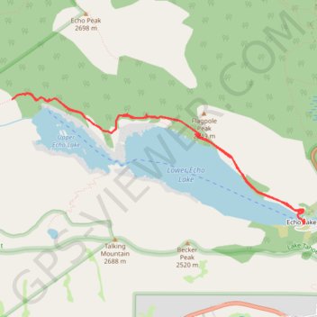
Upper Echo Lake and Lower Echo Lake
Hike from Echo Lake to Upper Echo Lake and Lower Echo Lake via Echo Pass Viewpoint and Pacific Crest National Scenic Trail (PCT) in the Lake Tahoe Basin Management Unit. #Hiking #Lake #Mountain #Nature #Forest #PCT #Overlook
- Distance: 9.6 Km
- Elevation gain: 273 m
- Maximum elevation: 2,327 m
- Elevation loss: 270 m
- Minimum elevation: 2,264 m
- Moving time: 4 h 10 m
- Moving speed: 2.3 Km/h
- Maximum speed: 4.2 Km/h
- Total time: 5 h 51 m
- Global speed: 1.6 Km/h
Interactive trail map
Trail profile
- Distance: 9.6 Km
- Elevation gain: 273 m
- Maximum elevation: 2,327 m
- Elevation loss: 270 m
- Minimum elevation: 2,264 m
- Moving time: 4 h 10 m
- Moving speed: 2.3 Km/h
- Maximum speed: 4.2 Km/h
- Total time: 5 h 51 m
- Global speed: 1.6 Km/h
About this trail
Name: Upper Echo Lake and Lower Echo Lake trail, distance, elevation, map, profile, GPS track
End: Echo Lakes Road, Echo Lake, El Dorado County, California, 95721, United States (38.83445 -120.04378)
Coordinates: 38.83430 -120.08339 38.84805 -120.04375
Other hiking, mountain biking, running and outdoor activity trails
Click on a trail to view its statistics, map and profile.
Desolation Wilderness 7 Summits Loop Hike
United States > California > El Dorado County
Ralston Peak, Pyramid Peak, Mount Agassiz, Mount Price, Jacks Peak, Dicks Peak and Mount Tallac.
Distance: 38.6 Km • Elevation gain: 2,956 m • Maximum elevation: 3,034 m