Thank you for supporting this site ❤️
Make a donation
Make a donation
Gear up for your next adventure:
As an Amazon Associate, this site earns from qualifying purchases at no extra cost to you.
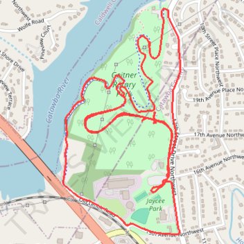
Geitner Rotary Park Loop
- Distance: 7.7 Km
- Elevation gain: 130 m
- Maximum elevation: 328 m
- Elevation loss: 130 m
- Minimum elevation: 288 m
- Moving time: 53 m 46 s
- Moving speed: 8.6 Km/h
- Maximum speed: 25.3 Km/h
- Total time: 58 m 21 s
- Global speed: 7.9 Km/h
Interactive trail map
Thank you for supporting this site ❤️
Make a donation
Make a donation
Gear up for your next adventure:
As an Amazon Associate, this site earns from qualifying purchases at no extra cost to you.
Trail profile
- Distance: 7.7 Km
- Elevation gain: 130 m
- Maximum elevation: 328 m
- Elevation loss: 130 m
- Minimum elevation: 288 m
- Moving time: 53 m 46 s
- Moving speed: 8.6 Km/h
- Maximum speed: 25.3 Km/h
- Total time: 58 m 21 s
- Global speed: 7.9 Km/h
Thank you for supporting this site ❤️
Make a donation
Make a donation
Gear up for your next adventure:
As an Amazon Associate, this site earns from qualifying purchases at no extra cost to you.
About this trail
Name: Geitner Rotary Park Loop trail, distance, elevation, map, profile, GPS track
Coordinates: 35.75367 -81.37508 35.76554 -81.36748
Thank you for supporting this site ❤️
Make a donation
Make a donation
Gear up for your next adventure:
As an Amazon Associate, this site earns from qualifying purchases at no extra cost to you.