Thank you for supporting this site ❤️
Make a donation
Make a donation
Gear up for your next adventure:
As an Amazon Associate, this site earns from qualifying purchases at no extra cost to you.
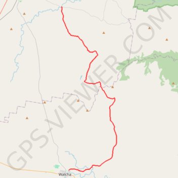
Gostwyck - Walcha
#Bike
- Distance: 49.2 Km
- Elevation gain: 578 m
- Maximum elevation: 1,157 m
- Elevation loss: 506 m
- Minimum elevation: 996 m
Interactive trail map
Thank you for supporting this site ❤️
Make a donation
Make a donation
Gear up for your next adventure:
As an Amazon Associate, this site earns from qualifying purchases at no extra cost to you.
Trail profile
- Distance: 49.2 Km
- Elevation gain: 578 m
- Maximum elevation: 1,157 m
- Elevation loss: 506 m
- Minimum elevation: 996 m
Thank you for supporting this site ❤️
Make a donation
Make a donation
Gear up for your next adventure:
As an Amazon Associate, this site earns from qualifying purchases at no extra cost to you.
About this trail
Name: Gostwyck - Walcha trail, distance, elevation, map, profile, GPS track
End: Jamieson Street, Walcha, Walcha Council, New South Wales, 2354, Australia (-30.97799 151.60161)
Coordinates: -30.97989 151.58610 -30.69520 151.69685
Topography: New South Wales topographic map, elevation, terrain
Thank you for supporting this site ❤️
Make a donation
Make a donation
Gear up for your next adventure:
As an Amazon Associate, this site earns from qualifying purchases at no extra cost to you.