Thank you for supporting this site ❤️
Make a donation
Make a donation
Gear up for your next adventure:
As an Amazon Associate, this site earns from qualifying purchases at no extra cost to you.
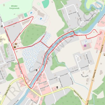
Minden Trails
- Distance: 5.5 Km
- Elevation gain: 27 m
- Maximum elevation: 284 m
- Elevation loss: 27 m
- Minimum elevation: 270 m
- Moving time: 30 m 52 s
- Moving speed: 10.8 Km/h
- Maximum speed: 13.9 Km/h
- Total time: 30 m 52 s
- Global speed: 10.8 Km/h
Interactive trail map
Thank you for supporting this site ❤️
Make a donation
Make a donation
Gear up for your next adventure:
As an Amazon Associate, this site earns from qualifying purchases at no extra cost to you.
Trail profile
- Distance: 5.5 Km
- Elevation gain: 27 m
- Maximum elevation: 284 m
- Elevation loss: 27 m
- Minimum elevation: 270 m
- Moving time: 30 m 52 s
- Moving speed: 10.8 Km/h
- Maximum speed: 13.9 Km/h
- Total time: 30 m 52 s
- Global speed: 10.8 Km/h
Thank you for supporting this site ❤️
Make a donation
Make a donation
Gear up for your next adventure:
As an Amazon Associate, this site earns from qualifying purchases at no extra cost to you.
About this trail
Name: Minden Trails trail, distance, elevation, map, profile, GPS track
Coordinates: 44.92552 -78.72880 44.93255 -78.71551
Thank you for supporting this site ❤️
Make a donation
Make a donation
Gear up for your next adventure:
As an Amazon Associate, this site earns from qualifying purchases at no extra cost to you.
Other hiking, mountain biking, running and outdoor activity trails
Click on a trail to view its statistics, map and profile.