Import a GPX file

San Mateo Peak

Hike to San Mateo Peak via Morgan Trail and San Mateo Peak Trail in the San Mateo Canyon Wilderness and the Cleveland National Forest. #Hiking #Mountain #Nature #Forest #Park

  • Distance: 3.6 Km
  • Elevation gain: 238 m
  • Maximum elevation: 1,077 m
  • Elevation loss: 33 m
  • Minimum elevation: 851 m

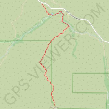
Interactive trail map

Trail profile

  • Distance: 3.6 Km
  • Elevation gain: 238 m
  • Maximum elevation: 1,077 m
  • Elevation loss: 33 m
  • Minimum elevation: 851 m

About this trail

Name: San Mateo Peak trail, distance, elevation, map, profile, GPS track

Start: Morgan Trailhead, Riverside County, California, 92530, United States (33.63355 -117.38303)

End: San Mateo Peak Trail, Riverside County, California, United States (33.61338 -117.37998)

Coordinates: 33.61338 -117.38356 33.63357 -117.37642

Other hiking, mountain biking, running and outdoor activity trails

Click on a trail to view its statistics, map and profile.

Morgan Trail and Morrell Canyon

United States > California > Riverside County > Lake Elsinore

Hike from Ortega Oaks via the Bear Canyon, the Morgan Trail and the Morrell Canyon in the San Mateo Canyon Wilderness and the Cleveland National Forest. #Hiking #Nature #Canyon #Mountain #Forest #Wilderness

Distance: 8.4 Km • Elevation gain: 349 m • Maximum elevation: 888 m

Gear up for your next adventure:

📻Handheld UHF Radios - Critical communication for groups in the Australian outback
Altimeter Watches - Watches with altitude tracking
📡Weather Radios - Emergency weather radios
🕯️Emergency Whistles - Safety whistles for hiking
👄SPF Lip Balm - Prevent sun and wind-burnt lips on mountain ridges

As an Amazon Associate, this site earns from qualifying purchases at no extra cost to you.