Import a GPX file

Dunrod Hill and Hillside Hill loop from Greenock West - Clyde Muirshiel Regional Park

  • Distance: 18.9 Km
  • Elevation gain: 410 m
  • Maximum elevation: 291 m
  • Elevation loss: 409 m
  • Minimum elevation: 16 m
  • Moving time: 1 h 41 m
  • Moving speed: 11.2 Km/h
  • Maximum speed: 21.9 Km/h
  • Total time: 1 h 43 m
  • Global speed: 11.0 Km/h

Interactive trail map

Trail profile

  • Distance: 18.9 Km
  • Elevation gain: 410 m
  • Maximum elevation: 291 m
  • Elevation loss: 409 m
  • Minimum elevation: 16 m
  • Moving time: 1 h 41 m
  • Moving speed: 11.2 Km/h
  • Maximum speed: 21.9 Km/h
  • Total time: 1 h 43 m
  • Global speed: 11.0 Km/h

About this trail
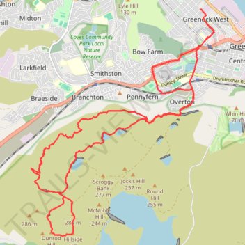
Name: Dunrod Hill and Hillside Hill loop from Greenock West - Clyde Muirshiel Regional Park trail, distance, elevation, map, profile, GPS track

Start: Ardgowan Square, Greenock West, Greenock, Inverclyde, Scotland, PA16 8ET, United Kingdom (55.95147 -4.76896)

End: Campbell Street, Greenock West, Greenock, Inverclyde, Scotland, PA16 8ES, United Kingdom (55.95379 -4.77056)

Coordinates: 55.91375 -4.82402 55.95379 -4.76618

Other hiking, mountain biking, running and outdoor activity trails

Click on a trail to view its statistics, map and profile.
Munro hillwalk Meall Dearg Sgorr nam Fiannaidh Aonach Eagach

United Kingdom > Scotland > Highland

#Munro #hillwalk #Meall #Dearg #Aonach #Eagach

Distance: 173.4 Km • Elevation gain: 2,915 m • Maximum elevation: 962 m

Gear up for your next adventure:

🎒3L Hydration Reservoirs - Hands-free drinking to stay hydrated on steep contour climbs
🎒Hiking Backpacks - Backpacks designed for hiking and trekking
🌬️Windbreaker Jackets - Wind protection jackets
🔥Windproof Plasma Lighters - USB rechargeable lighters that work in high-altitude winds
🧊Insulated Stainless Steel Flasks - Keep water cold for 24 hours in the heat or coffee hot in the cold

As an Amazon Associate, this site earns from qualifying purchases at no extra cost to you.