North Charlotte
Mapping this city for bikes is a never-ending task
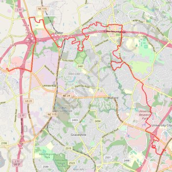
- Distance: 33.0 Km
- Elevation gain: 308 m
- Maximum elevation: 262 m
- Elevation loss: 309 m
- Minimum elevation: 184 m
- Moving time: 1 h 55 m
- Moving speed: 17.2 Km/h
- Maximum speed: 41.6 Km/h
- Total time: 2 h 2 m
- Global speed: 16.1 Km/h
Interactive trail map
Trail profile
- Distance: 33.0 Km
- Elevation gain: 308 m
- Maximum elevation: 262 m
- Elevation loss: 309 m
- Minimum elevation: 184 m
- Moving time: 1 h 55 m
- Moving speed: 17.2 Km/h
- Maximum speed: 41.6 Km/h
- Total time: 2 h 2 m
- Global speed: 16.1 Km/h
About this trail
Name: North Charlotte trail, distance, elevation, map, profile, GPS track
Coordinates: 35.30059 -80.85830 35.37691 -80.75025
Other hiking, mountain biking, running and outdoor activity trails
Click on a trail to view its statistics, map and profile.
Exploring Long Creek and McIntyre Creek
United States > North Carolina > Mecklenburg County > Charlotte
New Greenway and shoulder lanes
Distance: 28.0 Km • Elevation gain: 234 m • Maximum elevation: 248 m