Gravy Trail Whitewater
Field Trip/Gravy Trails
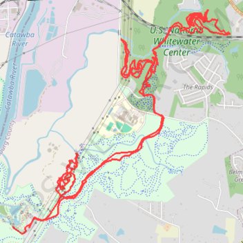
- Distance: 19.5 Km
- Elevation gain: 225 m
- Maximum elevation: 208 m
- Elevation loss: 225 m
- Minimum elevation: 177 m
- Moving time: 1 h 27 m
- Moving speed: 13.4 Km/h
- Maximum speed: 42.2 Km/h
- Total time: 1 h 32 m
- Global speed: 12.7 Km/h
Interactive trail map
Trail profile
- Distance: 19.5 Km
- Elevation gain: 225 m
- Maximum elevation: 208 m
- Elevation loss: 225 m
- Minimum elevation: 177 m
- Moving time: 1 h 27 m
- Moving speed: 13.4 Km/h
- Maximum speed: 42.2 Km/h
- Total time: 1 h 32 m
- Global speed: 12.7 Km/h
About this trail
Name: Gravy Trail Whitewater trail, distance, elevation, map, profile, GPS track
Start: North Main Loop, Mecklenburg County, North Carolina, 28120, United States (35.27084 -81.00499)
End: North Main Loop, Mecklenburg County, North Carolina, 28120, United States (35.27095 -81.00721)
Coordinates: 35.27013 -81.00724 35.29549 -80.97719
Other hiking, mountain biking, running and outdoor activity trails
Click on a trail to view its statistics, map and profile.
Whitewater Center various trail sure
United States > North Carolina > Mecklenburg County
Friday Morning Whitewater
Distance: 15.4 Km • Elevation gain: 221 m • Maximum elevation: 216 m