Make a donation
Gear up for your next adventure:
As an Amazon Associate, this site earns from qualifying purchases at no extra cost to you.
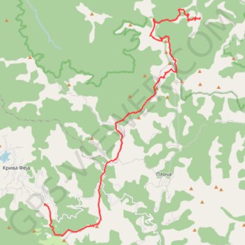
Besna Kobila (1923m)-Veliki Streser (1878m)-Topli Do hiking,...
- Distance: 27.1 Km
- Elevation gain: 1,067 m
- Maximum elevation: 1,907 m
- Elevation loss: 1,420 m
- Minimum elevation: 1,099 m
Interactive trail map
Make a donation
Gear up for your next adventure:
As an Amazon Associate, this site earns from qualifying purchases at no extra cost to you.
Trail profile
- Distance: 27.1 Km
- Elevation gain: 1,067 m
- Maximum elevation: 1,907 m
- Elevation loss: 1,420 m
- Minimum elevation: 1,099 m
Make a donation
Gear up for your next adventure:
As an Amazon Associate, this site earns from qualifying purchases at no extra cost to you.
About this trail
Name: Besna Kobila (1923m)-Veliki Streser (1878m)-Topli Do hiking,... trail, distance, elevation, map, profile, GPS track
Coordinates: 42.52456 22.19425 42.63930 22.30185
Make a donation
Gear up for your next adventure:
As an Amazon Associate, this site earns from qualifying purchases at no extra cost to you.
Other hiking, mountain biking, running and outdoor activity trails
Click on a trail to view its statistics, map and profile.
Besna kobila: od pl.doma na vrhove Musulj Čukar, Besna kobil...
Serbia > Central Serbia > Pcinja Administrative District > Vranjska Banja > Kriva Feja > Barje
Distance: 18.9 Km • Elevation gain: 939 m • Maximum elevation: 1,917 m
Trenutna trasa: 29 KOL 2015 09:15 001
Serbia > Central Serbia > Pcinja Administrative District > Vranjska Banja > Kriva Feja > Barje
Distance: 20.2 Km • Elevation gain: 943 m • Maximum elevation: 1,909 m
Vardenik: od fabrike 'Rosa', vrhovi Veliki Strešer, Mali Str...
Serbia > Central Serbia > Pcinja Administrative District > Surdulica Municipality > Vlasina Okruglica > Topli Do
Distance: 15.8 Km • Elevation gain: 900 m • Maximum elevation: 1,869 m
Fabrika Rosa - Veliki Streser 1876m -Mali Streser 1757m - Pa...
Serbia > Central Serbia > Pcinja Administrative District > Surdulica Municipality > Vlasina Okruglica > Topli Do
Distance: 17.0 Km • Elevation gain: 942 m • Maximum elevation: 1,869 m
Make a donation
Gear up for your next adventure:
As an Amazon Associate, this site earns from qualifying purchases at no extra cost to you.