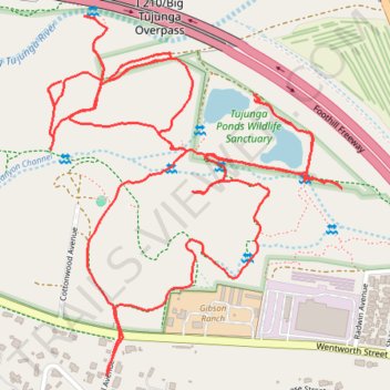
Big Tujunga Wash and Tujunga Ponds
- Distance: 5.5 Km
- Elevation gain: 40 m
- Maximum elevation: 370 m
- Elevation loss: 40 m
- Minimum elevation: 346 m
- Moving time: 1 h 21 m
- Moving speed: 4.1 Km/h
- Maximum speed: 7.8 Km/h
- Total time: 1 h 32 m
- Global speed: 3.6 Km/h
Interactive trail map
Trail profile
- Distance: 5.5 Km
- Elevation gain: 40 m
- Maximum elevation: 370 m
- Elevation loss: 40 m
- Minimum elevation: 346 m
- Moving time: 1 h 21 m
- Moving speed: 4.1 Km/h
- Maximum speed: 7.8 Km/h
- Total time: 1 h 32 m
- Global speed: 3.6 Km/h
About this trail
Name: Big Tujunga Wash and Tujunga Ponds trail, distance, elevation, map, profile, GPS track
Coordinates: 34.26337 -118.34586 34.27074 -118.33859
Other hiking, mountain biking, running and outdoor activity trails
Click on a trail to view its statistics, map and profile.
Big Tujunga Wash
United States > California > Los Angeles County > Los Angeles
Distance: 3.2 Km • Elevation gain: 35 m • Maximum elevation: 354 m
Big Tujunga Wash to Nature Area
United States > California > Los Angeles County > Los Angeles
Distance: 2.0 Km • Elevation gain: 25 m • Maximum elevation: 370 m
Big Tujunga Wash South
United States > California > Los Angeles County > Los Angeles
Distance: 2.3 Km • Elevation gain: 25 m • Maximum elevation: 370 m